ČERNÁ HORA - provozní řád plochy
I. Všeobecně
Letový terén Černá hora se nachází v oblasti východní části Krkonoš ve III. zóně Krkonošského národního parku (KRNAP). Jedná se o letový terén určený především pro výkonnostní termické létání padákových (PK) a závěsných (ZK) kluzáků. Veškerý pohyb v této lokalitě se řídí návštěvním řádem KRNAP.
II. Startovací plocha
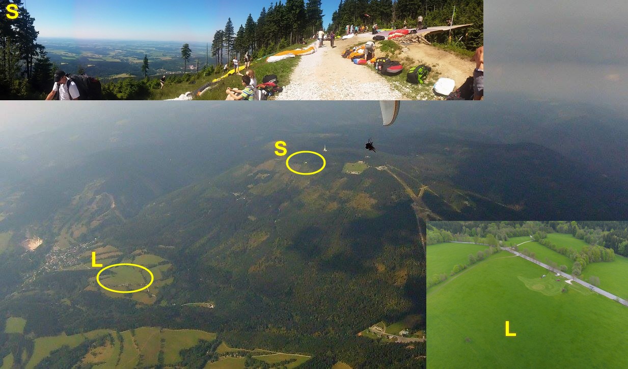
Na letovém terénu Černá hora se nachází jedno startoviště. Startoviště lesní průsek pod vysílačem.
Startoviště lesní průsek pod vysílačem:
Orientace startoviště: 183°
Nadmořská výška start. plochy: 1260 m. n. m.
Poloha středu startovní plochy: E 015° 44' 29,2'', N 50° 39' 00,7''
Přístup na startoviště: Lanovou dráhou na Černou horu z Janských Lázní, odtud k Sokolské boudě, dále po svážnici k lesnímu průseku pod vysílač.
Překážky v oblasti startu: Stromy vysoké cca 20 m pod startovištěm ve vzdálenosti cca 300 m a stromy po obou stranách startoviště (šířka průseku cca 90 m).
Obtížnost startu: PK - středně obtížný; ZK - mírně obtížný
III. Přistávací plocha
K dispozici je 1 přistávací plocha - louka U kapličky (P1).
Přistávací plocha U kapličky:
Poloha středu přistávací plochy: E 015° 43' 47,0'', N 50° 38' 05,0''
Nadmořská výška přist. plochy: 650 m n. m.
Přístup na přistávací plochu: V blízkosti silnice č. 297 z Janských Lázní do Černého Dolu.
Rozměry přistávací plochy: 200 x 40 m
Překážky v blízkosti přistávací plochy: Podél silnice vede telefonní vedení,v okolí místa přistání roztroušená zeleň.
Obtížnost přistání: PK - snadné; ZK - snadné, pozor na sklon !!!
IV. Létání
Časová omezení: Startoviště je možno používat celoročně, je třeba počítat s neupraveností startoviště a přistávacích plochy v zimním období.
Přistání mimo plochu: Přistání mimo oficiální přistávací plochy nejsou povolena. Dojde-li přesto, v případě nouzové situace, k přistání mimo tyto plochy, je pilot povinen na vhodné ploše sbalit kluzák a poté se vydat k nejbližší značené turistické stezce nebo komunikaci. Při této činnosti je jeho povinností zabránit jakémukoli ničení porostů. Nerespektování těchto zásad nebo úmyslné přistání mimo oficiální přistávací plochy bude klasifikováno jako porušování návštěvního řádu Krnap. Přistání do lesa a na strom – kontaktujte stanici Horské služby nebo správce plochy (viz Důležitá telefonní čísla).
Povolený směr a síla větru: 160°- 220°
PK: 0-8 m/s; ZK: 3 – 10 m/s
Převýšení: 570 m
Výcvik je dovolen po seznámení instruktorů s místními podmínkami u správce terénu, nebo inspektora PL LAA ČR – Miroslava Fejta (777666747).
Bezpečnostní pokyny: Rozsáhlý lesní porost, dodržovat dostatečnou výšku nad terénem. Na přistání je třeba po dosednutí co nejdříve opustit plochu pro přistání a balit na místě co nejblíže parkovišti. Nebezpečí zranění přistávajícími kluzáky!!
Umístění informačních tabulí: Spodní stanice lanové dráhy, startoviště S1, přistání P1.
V. Kontaktní spojení
Informace o aktivaci prostorů https://aisview.rlp.cz/ .
Informace o zvláštnostech Černé hory u správce startoviště - Martin Kobr +420 776 794 142
Nebo inspektor letového provozu PG LAA ČR Miroslav Fejt +420 777 666 747
ČERNÁ HORA
I. Allgemein
Das Fluggelände Černá hora befindet sich im östlichen Teil des Riesengebirges in der III. Zone des Nationalparks Krkonoše. Es handelt sich um ein für das thermische Leistungsfliegen mit Gleitschirmen(GS) und Hängegleitern(HG) geeignetes Fluggebiet. Sämtliche Bewegung in diesem Gebiet wird durch die Besucherordnung des Nationalparks Krkono'e geregelt.
II. Startplatz
Im Fluggebiet Černá hora befindet sich ein Startplatz. Startplatz Durchhieb im Wald unterhalb des Senders.
Startplatz Durchhieb im Wald unterhalb des Senders:
Orientierung des Startplatzes: 183°
Seehöhe des Startplatzes: 1260 m ü. M.
Lage des Mittelpunktes: E 015° 44' 29,2'', N 50° 39' 00,7''
Auffahrt zum Startplatz: Mit der Seilbahn auf die Černá hora von Jánské Lázně, von hier aus zur Baude Sokolská, weiter auf dem abschüssigen Pfad zur Schneise unterhalb des Senders.
Hindernisse: Bäume, ca. 20 m hoch unterhalb des Startplatzes in einer Entfernung von ca. 300 m und Bäume zu beiden Seiten des Startplatzes (eine ca. 90 m breite Schneise).
Startschwierigkeit: Gleitschirme - mittelschwer, Hängegleiter - leicht schwierig
III. Landeplatz
Zur Verfügung steht ein Landeplatz. Wiese U kapličky (an der Kapelle) (P1).
Landeplatz An der Kapelle:
Lage des Mittelpunktes: E 015° 43' 47,0'', N 50° 38' 05,0''
Seehöhe des Landeplatzes: 690 m ü. M.
Anfahrt: In der Nähe die Straße Nr. 297 von Jánské Lázně nach Černý Důl.
Ausmaß: 200 x 40 m
Hindernisse in der Nähe des Landeplatzes: Telefonleitung an der Straße entlang, in der Umgebung des Landeplatzes verstreute Bäume
Landungsschwierigkeit: Gleitschirme - leicht; Hängegleiter - leicht, Acht geben auf die Neigung!!!
IV. Fliegen
Landen außerhalb der Landeplätze: Das Landen außerhalb der offiziellen Landeplätze ist nicht erlaubt. Wenn man trotzdem im Notfall außerhalb dieser Gelände landen muss, ist der Pilot verpflichtet, den Gleiter am angemessenen Platz zusammenzupacken und zum nächsten markierten Pfad oder zur Straße zu gehen. Bei dieser Tätigkeit sollte der Pilot dem Vernichten von Waldbeständen vorbeugen. Die Nichteinhaltung von diesen Grundsätzen oder die absichtliche Landung außerhalb der offiziellen Landeplätze wird als Übertretung der Besucherordnung des Nationalparks Krkono'e qualifiziert. Landen in den Wald oder auf den Baum - treten Sie in Verbindung mit der Station des Bergrettungsdienstes oder dem Verwalter des Fluggeländes (s. Punkt V.).
Erlaubte Windrichtung und -stärke: 160°- 220°
Gleitschirme - 0-8 m/s
Hängegleiter - 3 m/s - 10 m/s
Höhenunterschied: 570 m
Schulung: Im Fluggebiet sind alle Schulungsflüge verboten. Mit Ausnahme von Übungsflügen des Instruktors mit seinem Schüler auf dem Zweisitzer.
Sicherheitsinstruktionen: großflächiger Waldbestand, Sicherheitshöhe halten.
Informationstafeln: Talstation des Skilifts; Startplatz 1
V. Kontaktverbindungen:
Gleitschirm fluginspektor : Miroslav Fejt +420 777 666 747
ČERNÁ HORA
I. GENERAL INFORMATION
The flying area Černá hora is situated in the eastern part of the Krkonoše Mts.,in the zone III of Krkonoše National Park (KRNAP). This flying are is determined especially for sport and advanced termical flying of paragliders (PK) and hang-gliders (ZL). All activities in this area are abode by The Rules of Visits to the Krkono'e National Park.
II. STARTING PLACE
In the flying area Černá there is a starting place - eastern orientation - forest path under the transmitter:
S - Starting Place Forest Path under the Transmitter
Starting place Orientation: 183°
Elevation: 1260 m.a.s.l.
GPS Position: E 015° 44' 29,2'', N 50° 39' 00,7''
Approach to Starting Place: chair-lift to Černá hora top from Jánské Lázně - Sokolská bouda house - way to forest path under the transmitter
Obstacles: Trees prox. 20 m high under the starting area in the distance prox. 300 m ; trees on both sides of starting place ( forest path is 90 m wide)
Start - Difficulty: PK - medium difficult, ZK - medium difficult
III. LANDING AREA
There is a landing area - U kapličky (by the Village chapel) meadow (P)
P - Landing area - U kapličky (by the Village chapel)
GPS Position: E 015° 43' 47,0'', N 50° 38' 05,0''
Elevation: 690 m.a.s.l.
Approach: near the road 297 from Jánské lázně to Černý důl
Size: 200 x 40 m
Obstacles: following the road there is a telephone line, trees around the landing area
Landing - Difficulty: PK - easy; ZK - easy (attention - slope !!!)
IV. FLYING
Time restriction: Starting place is all the year round available. The starting place and the landing place is not groomed.
Landing outside area P: Landing outside the official landing areas is prohibited. When a pilot lands outside the official landing areas - in case of emergency - he must pack up his chute on a suitable place and find the nearest marked path or road. He is owed not to destroy the growth. Unobserving of these regulations or intentional landing outside the permitted landing areas is considered as The Rules of Visits to the Krkono'e National Park trespassing. Landing into the forest and on the tree - call the Mountain Rescue Service ( point V.)
Direction and power of wind limits: 160°-220°
PK: 0-8 m/s; HG: 3 - 10 m/s
Elevation change: 570 m
Lessons: Giving lessons is prohibited in this flying area. Flights - instructor and pupil on the tandem PK/ZK are allowed on the condition that the instructors pilots all flight
Safety rules: Large forest area, keep the necessary height above the terrain.
Info board location: - bottom ski-lift station; starting place S
V. INFORMATION
Flying inspektion : +420 777 666 747 Miroslav Fejt